A student-made map to navigate campus
The new online campus map is packed with useful information, can be easily read on a smartphone — and was created by a student.
By Sasha Nyary
In the spring of Sarah Robinson’s first year at Mount Holyoke College, a web development job on campus with LITS, Library, Information and Technology Services, opened up.
The position involved working on the College website with the web services and application development team. During the application process, Robinson, class of 2017, was asked to consider a list of projects the team was considering, choose one and suggest improvements.
Robinson chose the online campus map and not only got the job but eventually became the project’s lead programmer as well. The new map, now an updated and much more versatile tool for both members of the College community and visitors, launched this spring.
It was immediately clear at the interview that Robinson had unusual abilities and talent, said Sven Aas, the lead web applications developer at LITS.
“We’ve been very fortunate to be able to always hire exceptional students who are active and engaged,” Aas said. “But Sarah is very exceptional. It was very clear right from the interview that Sarah would be capable of pursuing whatever direction they were interested in pursuing.”
Robinson, who uses gender-neutral pronouns, realized they wanted a future in computer science while attending Stuyvesant High School in New York City. When they took the school’s required computer science class, to their surprise, they loved it. When it came time to look at colleges, Mount Holyoke stood out, said Robinson, a computer science major with a math minor.
“I was looking specifically for colleges with computer science, but also colleges with liberal arts so I could get more of a breadth of education,” said Robinson, who was also drawn to Mount Holyoke’s membership in the Five College Consortium.
Robinson’s skills and interest made for a great team member, said Aas and Jason Proctor, the senior web applications developer who worked closely with Robinson.
“Sarah’s capable of a great degree of proactive, independent work,” Aas said. “When Sarah didn’t have something more pressing, they would document what they found or write up lists of requirements and ideas. Every time Sarah came to work, they would review the latest team messages and offer responses and solutions. Sarah looked for opportunities to help. We never asked them to do that.”
Robinson’s deep skills meant they were involved on several projects over the course of their time working at LITS. Subsequent summer internships at Google — “one internship is hard to land, two is unheard of,” Aas said — including one at Google Maps, gave Robinson even more expertise to bring back to the LITS team. This August, Robinson will be headed back to Google once more: as a full-time software engineer.
As a senior, Robinson had enough skills and experience to take on a lead role coordinating the work of the map project, including overseeing the work of the other students on the team. In particular, Mahima Ghale ’17 worked on early research and development that served as the basis for the map’s eventual path forward, and Amna Aftab ’17 worked on sourcing and importing additional geographic data in order to supplement campus information with surrounding landmarks.
In addition to having worked at LITS for three years, Robinson is the president of Bellatrix MHC, the College’s science fiction anime and comics club; was a member of the MaGE (Megas and Gigas Educate) peer mentorship program; was involved with the recent Girls in Tech conference; and volunteered at HackHolyoke, the College’s hackathon.
“Because Mount Holyoke is a liberal arts college, I think we develop broader technical skills,” Robinson said. “That means a lot more design-based skills and group-project skills like communications and project management, and being able to talk to someone who is not a computer scientist about what you’re doing.”
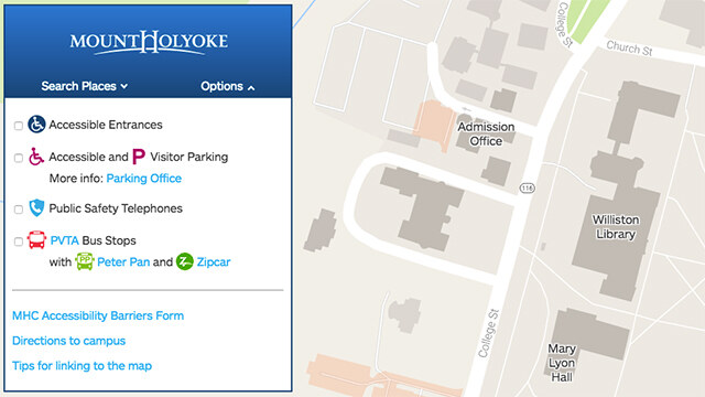
Robinson had a chance to practice those skills at meetings with the map’s stakeholders across campus as they worked on developing its many up-to-date features. The map provides campus geographic information in the familiar layout of a Google map and also includes the names and locations of every building and academic department. And the map is responsive, meaning it can be used on a smartphone or tablet as easily as a desktop or laptop.
“The data comes from Facilities Management, the content comes from Communications and Marketing, and we put it together,” Robinson said. “It’s designed to be easy to update. The people in Facilities say, ‘We have new data for you.’ We add it to the map, test it and launch it.”
For those who are technically inclined, the map was built in JavaScript and jQuery, which is a library for JavaScript, with Python for preprocessing the data from Facilities Management. Google Maps provides the main library, but it’s not exactly the same as the Google map for the local area.
“Google gave us a map where we can put our buildings and all the data on top of it,” Robinson said. “Our map shows where all the bus stops are, what’s closest to the building where I have class? Where is Admission? Where is the Art Museum? Where is parking and what parking is accessible? And there’s a link on our map that takes you to Google Maps.”
In addition, the College’s new map conveniently separates out commonly viewed sites on campus, especially locations where public events are often held. Other helpful features include links to parking and accessible building entrances, public safety phones, Zipcar locations and bus stops.
For future iterations, the team is exploring questions such as how the new Community Center, which is under construction, should be included on the map, whether the map can include things like bike racks and other features the community might want to see.
“If Facilities can get us the data, we can add it,” said Robinson, noting that the map includes a convenient link to a feedback form on the lower left corner. “We just need a data source. Once the data is updated, we can add an icon and the map will say, for instance, here are the places you can park your bike.”
Robinson has handed off the map to LITS colleagues and is looking forward to the next project.
“Personally, I just want to see holograms,” Robinson said. “One of the things I’m waiting for is interactive holograms. I want my wrist computer that projects holograms for me.”
No doubt Robinson will be at the forefront of developing that technology as well.
What will you invent? Learn more.